Hujingyu Recreational Area Introduction
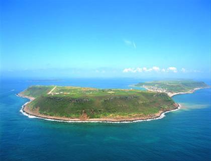
Hujing Island is the seventh largest island in the Penghu archipelago, located 7 nautical miles from Magong City. The island features spectacular basalt columnar joints. One of the "Eight Sceneries of Penghu," Hujing Chengyuan, offers a clear view of the sea bottom from the cliffs during low tide. According to legend, a tiger once hid in a dried-up cave on the southeast side of the island, which is how it got its name "Hujing." There is also an explanation suggesting that the well on the island, known for its sweet spring water, is called "Haojing," which is a homophone of "Hujing" in Minnan dialect; however, these explanations remain unverified and are only for reference and contemplation. The entire island is divided into two mountains, with villages located between the east and west mountains on a narrow land formed by coral debris. The eastern mountain is currently a military restricted area, while the western mountain has been designated as a park and recreation area by the Penghu Administration after the military's strategic withdrawal, retaining remnants of trenches constructed by the Japanese army during World War II. This location has recently been mistakenly referred to as the "Southern Command Center of Isoroku Yamamoto," when in fact only a small naval team commanded by a lieutenant was stationed there. Mentioning Hujing Island brings to mind the legend of "Hujing Sunken City," which leaves many questions unanswered. The legend speaks of a dilapidated city wall hidden at the bottom of the Hujing sea, the truth of which remains a mystery. This has led to two divergent opinions in academia: one theory suggests that the ancient sunken city is actually a geological formation of bucket-shaped basalt columns that extend into the sea, creating the illusion of a sunken city; the other theory posits that historical records are not groundless, as there are numerous legends in folklore about the unusual landscape, adding to the mystique of Hujing Island.


