Tongpan Geopark Introduction
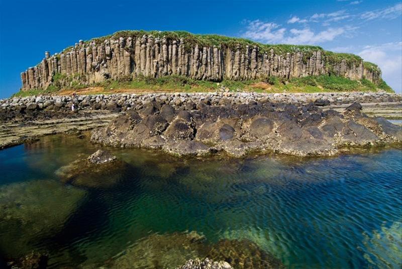
Tongpan Island is located approximately 6 nautical miles from Makung Island. The entire island is surrounded by striking columns of basalt, which are remarkably developed in their columnar jointing, making it one of the best examples in Penghu, earning the nickname "Yellowstone Park of Penghu." The columnar and plate jointing on the island is well-developed, originally appearing hexagonal or pentagonal. Due to severe weathering and erosion, the edges of the rock columns have become rounded, with some basalt columns having weathered into spherical shapes at their tops. The southwestern coastal area of Tongpan features a sea-eroded platform with concentric circular lava outlets formed by basalt lava flows, where a central dome-shaped rock resembles a lotus pedestal, known as the "Lotus Seat," which is revealed and concealed with the ebb and flow of the tides, showcasing a unique topographical feature of Penghu. A popular spot for stargazing is the "Bolang Coffee Drum" advertisement, where Tongpan Island's silhouette fills the screen alongside the powerful drum sounds and majestic basalt. The basalt columns of Tongpan Island have become the subject of numerous travel programs and advertisements, with the imposing columnar jointing being the most representative and unique element of Penghu.


