Dadong Mountain Range Hiking Trail Introduction
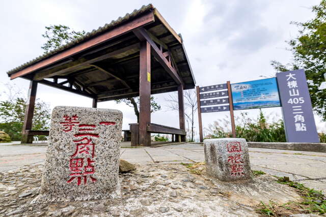
Deng Gao Wang Yuan 405 Heights: The Multiple Views of Dabang Mountain Dabang Mountain is located at the junction of Taoyuan and New Taipei, with an elevation of 405 meters, making it one of Taiwan's Minor 100 Peaks. Due to its prominent terrain, it is known as "405 Heights." At the summit, there is a first-class triangulation point, providing an expansive view that stretches from Taoyuan City, through the skyline of New Taipei, to Taipei 101. On clear days, the view is broad, and the night scenery is brilliant, making it a popular destination for hiking, photography, and sightseeing enthusiasts. Multiple Paths to Wander: Temples and Serene Mountain Forests The Dabang Mountain system features several popular hiking trails, one of which begins at the Yuanguang Bridge. The Fuyuan Mountain Trail weaves through greenery, reaching the summit in approximately 4.3 kilometers. A side trail, Shiyun Road, leads to the historic Shiyun Zen Temple, characterized by intricate carvings, winding stone steps, and shaded areas with ancient trees that add a sense of stability and cultural charm to the hike. Upon returning to Datong Road, visitors will occasionally encounter the Xukong Zen Temple and mountain restaurants, providing a dynamic change of scenery that enriches the journey. Another favored route enters from the Tukeng Industrial Road, stretching about 3.2 kilometers. Along the way, religious buildings like the Jichuong Zongshu Taoist Temple and Qianfo Temple are scattered in the mountain forests, appealing to travelers who appreciate serene atmospheres. Unique Natural Connections: Dahu Keng Nature Trail Located within the Dabang Mountain Scenic Area, the Dahu Keng Trail stretches approximately 1.4 kilometers, connecting Guishan Datong Road and New Taipei Shulin Minhe Street, as well as linking with the "Taipei Skyline" route to create a more complete mountain trail network. The trail design incorporates local cultural and natural characteristics, not only enhancing friendly and accessible pathways but also adding historical information on coal mining, as well as ecological explanations featuring dragonflies and damselflies along the route. The interpretive facilities are made from natural materials, including signboards arranged in the shape of dragonflies and tactile display areas composed of various woods, making the walking experience both intellectual and enjoyable. Some segments of the trail are constructed as "handcrafted paths," where local residents assist in using stones and wood gathered from the area, shaping the most natural walking trajectory based on the terrain to reflect the harmony between humans and the environment. Ultimate Summit View: A Collection of Seasonal Landscapes Upon reaching the 405 Heights, the observation platform, triangulation point, and hydrological observation information are all presented. To the east, the Snow Mountain Range and Dahan River can be seen, while Guanyin Mountain and Linkou Plateau lie to the west. To the south is Zhongli and the Fuxing Mountain area, and to the north, the Tamsui River and Yuanshan Hotel are visible, providing breathtaking panoramic views. The seasonal changes at Dabang Mountain further enhance the hiking experience: butterflies flutter in spring and summer, autumn brings waves of silvergrass, and winter showcases the red of maple trees. Travelers can also connect to the Datong Mountain Trail to head toward Qinglong Ridge or take the Kuan Gong Ridge Butterfly Trail to appreciate over 30 species of wild butterflies, adding vibrancy and color to the entire journey.


