Emperor Temple Hiking Trail

Taipei Attractions

皇帝殿山東峰為一裸露岩脊
皇帝殿山東峰為一裸露岩脊

Enjoy the stunning views of Shiding from the ridgeline, accompanied by the chirping of birds, making it a popular hiking trail.

Address:106乙 County Road, Shiding District, New Taipei City 223, Taiwan

Emperor Temple Hiking Trail Introduction
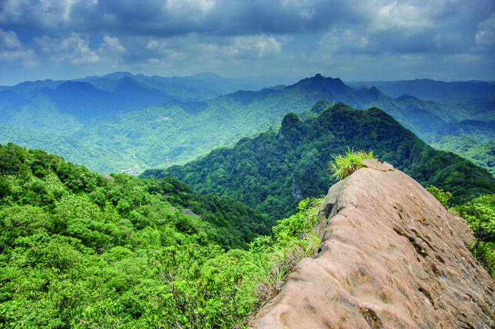
The Huangdi Dian Hiking Trail is located in the Shiding District of New Taipei City and is a ridge that extends northward from the Xueshan mountain range. Its most famous feature is the rock ridge trail between the East Peak and the West Peak, named after the Tianwang Temple located below the ridge, which is also known as the Huangdi Dian (Emperor's Palace). The term "Huangdi Dian Mountain" generally refers to the entire narrow rock ridge from East Peak to West Peak. The ridge top is so narrow that it resembles a knife-cut and is only wide enough for one person to pass through. On one side, there is a nearly vertical cliff, while on the other side is a slope that is parallel to the ground level. Most people tend to slow down while walking, with some even crawling, hence the mountain community describes it as "ants crossing the threshold." Some of the more hazardous sections are equipped with chains, ropes, and iron railings for safety, yet it still provides an exciting and thrilling experience, making it a very popular hiking route. The geology of the mountainous area is in its youthful phase, featuring special landscapes such as cliffs and deep gorges. Among them, the Yongding Shiba Peak, which directly points towards Shiding, has a linear distance of 4 kilometers, making it a rare rock climbing site. The East Peak is 593 meters high, the West Peak is 560 meters, and Tianwang Peak (Middle Peak) is 562 meters. Tianwang Peak is positioned right in the center of this ridge, with a yellow flag at the top bearing the words "Tianwang Temple." Although the mountains in this area are not very high, the northern views are excellent; on clear days, one can see Sifenziwei Mountain to the north and, farther to the northwest, the Qixing Mountain and Huangaijiao Mountain.

Emperor Temple Hiking Trail Travel Information

Address:106乙 County Road, Shiding District, New Taipei City 223, Taiwan


Transportation Methods:1. You can take the Kuo-Kuang Bus Route 666 from Jingmei or Muzha, and get off at the Huangdidian Station after crossing the Jiuliaopu Bridge. It's a 1.3-kilometer walk to the trailhead. For the return trip, if you are heading back to Xiau Cukeng, you can take the bus from the same location. If you get off at Yongding Elementary School, you will need to catch a Taipei Bus Pingxi Line. 2. Taipei Bus Pingxi Line: It mainly starts from Ma Ming Tan in Muzha (also available from Shulin and Banqiao) and goes through Shen Kong, Shuangxi Kou, and Wenshan Coal Mine before stopping at Yongding Elementary School. From there, walk 100 meters forward to find the Yuntai Mountain archway on the right side of the road, and follow the access road for 2.2 kilometers to reach the trailhead.


Remarks:1. Estimated time of the route: 4 hours 2. Trail difficulty level: Challenging (suitable for those with good physical fitness, some sections require climbing), Wilderness Adventure (mainly consists of primitive natural dirt and stone paths with low usage facilities, suitable for traversing difficult natural obstacle terrains or for those with climbing ability)


Other Nearby Attractions: Shiding Wulu Caishen TempleWenshan Coal Mine Bus StationJingtong Sky Lantern MuseumJingtong Old StreetJingtong Railway Story HouseJingtong Coal Mine Memorial ParkShihding Century Stone HouseStilt HouseHA SOCK Sock Doll Specialty StoreShih Chien Danlan Arts and Cultural Center


Nearby Cuisine: Shan Ting Diner Salt and Crispy Pork KnucklesSan Tsai Lingzhi FarmPalace Tea HouseGrandma's Japanese Ice (Zhongpu)Jingtong Old Street Red Gem Miner's DinerHot Spring Shop Chicken Roll StallChiao Men BakeryShiding Mace SausageMei Mei RestaurantFubao Restaurant


Recommended Hotel Bookings