Qixing Mountain Range_Tienmu Ancient Trail Introduction
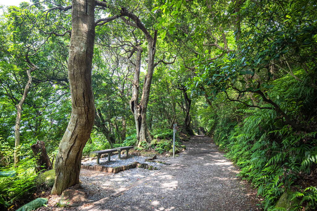
The Tianmu Trail passes through the northwestern hillside of the Shilin Huagang area, also serving as the saddle south of Shamao Mountain. It is part of the latter section of the ancient fish route, encompassing several trails between Huagang and Tianmu, constructed along the main water pipeline. The gentle streams and pristine forest scenery provide a refreshing and comfortable walking experience. The trail also connects to the Cuifeng Trail, which leads to Cuifeng Waterfall and is particularly cool and pleasant to walk through the shaded forest. The Tianmu Trail used to be an important pathway connecting Jinshan and Tianmu. Since the opening of Yangde Boulevard, this ancient shortcut has become a genuine historical path, and in recent years it has turned into a popular hiking route, attracting many visitors on weekends. The ecological landscape of the Tianmu Trail ranges in elevation from about 300 meters to 120 meters, belonging to Taiwan's low-altitude subtropical broadleaf forest ecosystem. The northeast monsoon winds from Datun Mountain bring strong winds, rain, and cool temperatures, creating temperate broadleaf forest scenery on the windward side of the ancient trail; conversely, the leeward side and valley environment favors the growth of tropical broadleaf species, such as tropical buttressed trees, lianas, and other vegetation. Although the Tianmu Trail is only at 300 meters elevation, it hosts a rare and valuable compressed ecosystem environment with various tropical, subtropical, and warm-temperate broadleaf forests. ◎ Special reminder for hikers: Near the branch path that leads down to Cuifeng Waterfall, you may encounter a group of monkeys. When you see them, please do not feed them indiscriminately, as they may fight over food and accidentally harm you! The Water Pipeline Trail has been a vital water source area in the Bao'an forest region since the Japanese colonial period. Not only does it have a rich and original forest ecosystem, but it also features abundant vegetation such as ferns and taro plants growing along the way. The water pipeline was built to convey spring water from the third water source to the areas of Tianmu and Shilin. The initial uphill section of the trail no longer shows the large water pipeline, while the later section has the pipeline buried beneath the trail. In the 1930s, stone slabs and cement were laid over the pipeline for protection, thus forming the water pipeline route, which eventually diverged from the trail as the terrain flattened in the Tianmu area. The entrance of the trail at the Sanjiao Pu Power Plant marks the beginning of the trail and the end of the water pipeline. Before entering the forest, hikers must first face the challenge of climbing over a thousand stone steps. Along the way, warm tea and soup are offered for free tasting, and once you feel warm, sun hats appear for your use. If you are thirsty, juice, tea, and sweet potato soup await you in the forest. Interestingly, before reaching Yangmingshan, local vegetables, bamboo shoots, and sweet potatoes are already lined up. The so-called "over a thousand steps" can be considered as a warm-up before entering the forest. The first thing you see is the longan tree forest, with tall longan trees flanking both sides of the stone steps, some trunks thick enough for two people to embrace. Longan used to be the main industry in this area. As you continue up, the legendary black water pipeline appears, and the mountain path suddenly becomes steep. Climbing uphill takes some effort, but there are resting pavilions along the way where you can pause. Looking back from the pavilion halfway up, you can see the Tianmu urban area at the foot of the mountain, giving you a sense of accomplishment even if you're a bit out of breath. If the weather is clear, you can enjoy a distant view of Linkou Terrace from the trail's end. Finally, after finishing this steep section, you can wash your face and wipe off the sweat by the reservoir before entering the cool and shaded flat path. Most visitors to the Water Pipeline Trail develop a fondness for this route. The trees provide shade, making summer hikes feel especially cool and comfortable; in winter, you can hear the north wind roaring through the valley, but it doesn’t feel particularly cold. The trail surface is level, making it perfect for stopping to enjoy the scenery. Walking along the forest path, your view transitions from overlooking Tianmu and Beitou to the mountain and valley, creating a picturesque landscape of terraced fields and curling mist. The Water Pipeline Trail, though only 300 meters high, has been a "water source area" and a "protected forest region" since the Japanese colonial period, thus preserving a rich and original forest ecosystem. Along the way, you can see many indicator plants like ferns and taro that thrive in this environment, and over 300 plant species can be found living here, showcasing the excellent protection of the ecological environment. On the rocky cliffs beside the trail, you may find stone stacks, and the mountain spring water flowing from the rock faces attracts shrimp and tadpoles. There is also a small ditch towards the end of the trail, with clear water that comes from the springs above, where numerous freshwater shrimp and crabs are found, serving as breeding grounds for various dragonflies and frogs. From autumn to early spring, you can often hear the calls of the elegant wrinkled frog, which sound like birdsongs. In the early mornings or at dusk, there’s also a chance to spot Formosan macaques. The babbling water of the Water Pipeline Trail originates from the Japanese colonial period and was opened to convey spring water from the third water source to the Tianmu and Shilin areas. Walking along the mountain path carved into the cliff, you won't see the large water pipeline from the earlier steep section, but the pipeline is buried beneath the later part of the trail. In the 1930s, stone slabs and soil were laid over the pipeline for protection, which solidified the water pipeline route. Approaching the Tianmu area, the terrain gradually flattens, leading the water pipeline and the trail to "part ways." Now, along the path next to the cliff, you can see ditches made of stones that guide the mountain spring water, reminiscent of the past usage of the water pipeline. Standing beside the water pipeline on the uphill path, you can hear the rush of water flowing inside the large water pipeline. The Sanjiao Pu Power Plant at the trail's entrance serves as both the starting point of the trail and the endpoint of the pipeline, witnessing the evolution of this waterway.


