Taixing Waterfall Trail Introduction
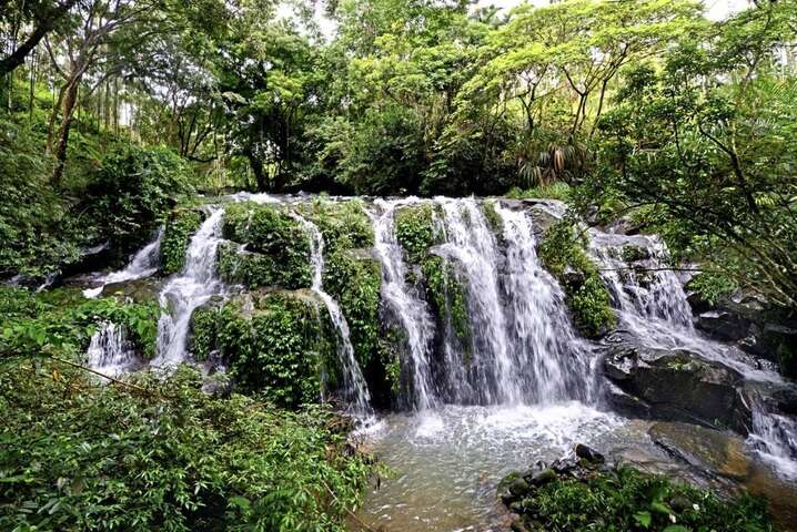
The trail to Ayah Creek Waterfall, formerly known as Ayah Creek Trail, was reconstructed by the Alishan National Scenic Area Administration and reopened in September 2018. Entering from the western end of the trail, you descend along wooden steps, accompanied by the sound of flowing water, and soon reach a viewing platform for the waterfall. The rustic wooden tables and chairs provided there not only allow for a rest but also serve as an ideal spot for tea gatherings. Continuing along the wooden walkway beside the creek through tea gardens and shaded areas, you will find a pavilion for resting. On the stone bridge crossing the stream, you can observe the rock strata and the direction of the water flow. Beyond the stone bridge lies the second section of the wooden steps, where you can enjoy views of the third-tier waterfall. A large platform here allows you to fully appreciate the beauty of the Taixing Waterfall. The Ayah Creek Waterfall consists of three tiers, with heights ranging from 10 to 20 meters. On the exposed rock surface, there are several channels carved by the stream. As the water flows down these channels from the top of the rock, it forms cascades like white ribbons, accompanied by green moss growing on the rocks, creating a beautiful scene that has earned it the title of "Taiwan's version of Jiuzhaigou Pearl Beach." After enjoying the stunning waterfall views, continue down the trail to reach an access road that connects to it. A short walk along this road brings you to the Xinglu Suspension Bridge, which offers beautiful scenery as well. On the opposite bank, near Nongxing Temple, there is a stone with the inscription "Stone Mill for the World's Grains" and a stone mill, a reminder of the area's rich historical and cultural heritage dating back to the Daoguang period of the Qing Dynasty. DATA Trail length: Approximately 700 meters Walking time: About 25 minutes one way Challenge level: Level 1 (Family-friendly) ◼️ Entrance A - Western trailhead GPS: 23°32'59.3"N 120°38'03.3"E Western parking lot GPS: 23°32'59.1"N 120°37'59.2"E ◼️ Entrance B GPS: 23°33'05.5"N 120°38'14.8"E


